Strong to historic El Niño possible through the winter
Likely results in a wet winter for Alabama and the Deep South
MONTGOMERY, Ala. (WSFA) - Winter 2023-24 will be characterized by El Niño. According to the Climate Prediction Center, a division of the National Oceanic and Atmospheric Administration (NOAA), El Niño is nearly guaranteed to last through winter.
There’s a 62% chance that it lasts all the way through spring of 2024.
It isn’t just a plain old El Niño event either. According to NOAA, the threshold for a “strong” El Niño has been met. There’s a greater than 55% chance that El Niño remains “strong” through March of next year.
Experts with NOAA say there’s roughly a 1-in-3 chance that El Niño reaches “very strong” strength. In the 73 years of data, this threshold has only been met four other times!
So what does all mean for us?
Well, El Niño impacts the the weather patterns across the U.S. This is especially true during the winter season, which we’re of course heading towards. It’s important to note that things don’t play out the exactly same each time there’s an El Niño.
Every El Niño event is different, and it’s impossible to tell you exactly how El Niño will affect our day-to-day weather this winter. However, I can tell you some things about our winter given the strength of this event and the current status of it.
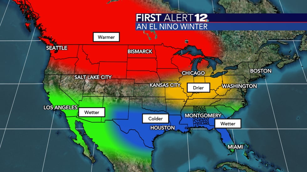
A typical El Niño winter brings wetter than normal conditions and colder than normal conditions to most of Alabama and the Deep South. That doesn’t mean every day will be wet, nor does it mean every day will be chilly.
Those are just the overall pattern trends we notice in Central and South Alabama during an El Niño winter.
The classic storm track during an El Niño winter stretches from the Desert Southwest to southern Texas to the Gulf Coast and into the southwestern Atlantic Ocean. This can be seen in the graphic above.
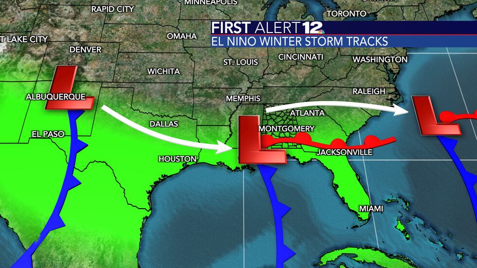
Not every area of low pressure and system we see will take that exact path; many of them will though. As a result, much of Alabama will be in an active zone with plenty of opportunities for rain. This storm track is good for us because it shoves the main risk of severe weather to our south.
Severe weather events can still happen, as is always the case in Alabama. They’re just muted a bit when an El Niño is in place!
Another aspect of El Niño is the colder temperatures. Does that result in increased snow chances for us? There’s no guarantee, but if you’re a fan of wintry weather then having an El Niño in place like we do now is a great start.
Only time will tell, snow lovers! Just sit back and hope we get the right storm track at the right time (with cold air in place). I’ll do my best to make that happen -- we’re overdue for some snow!
Not reading this story on the WSFA News App? Get news alerts FASTER and FREE in the Apple App Store and the Google Play Store!
Copyright 2023 WSFA. All rights reserved.